


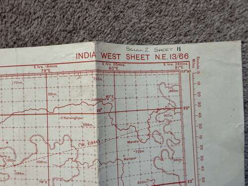


WWII 1945 British War Office India Madras Military Plotting Map GSGS 4080
Delivery Quote Request
Please fill in the form below to request a delivery quote from Mad Mantiques.
Contact Mad Mantiques
 www.madmantiques.co.uk, United Kingdom
Simply fill in the below form to get in touch with Mad Mantiques regarding this item.
About this item
Original Second World War British War Office military plotting map of India, prominently including Madras – modern-day Chennai – and the southeast Indian coastline.
Official title:
INDIA WEST – Sheet N.E. 13/66
Produced by the Geographical Section, General Staff (GSGS) as part of the military No. 4080 Plotting Series.
The printing details read:
Geographical Section, General Staff No. 4080
Published by War Office, 1941
4th Edition, 1945
15,000/3/45
This indicates this particular edition was printed in March 1945, during the final months of the Second World War.
The map covers a substantial area of southern and central India and includes Madras, together with locations including Jubbulpore, Mandla, Narsinghpur and Pulicat, plus the Bay of Bengal coastline.
Printed predominantly in red, it incorporates the extensive military plotting grid, latitude and longitude, navigation/plotting circles, relief and height information and geographical features characteristic of these wartime GSGS maps.
The margin additionally states:
“Drawn at War Office and Heliographed at O.S. 1941.”
There is a handwritten collection notation “Scull 2 Sheet 11” to the upper margin, matching the numbering found on the other maps from this group and suggesting they were retained together as a collection or working set.
ConditionGood original used condition for an approximately 80-year-old military map. Numerous original storage folds with associated creasing, some age-related staining/marks and minor edge wear. Small areas of wear are visible around some folds. Handwritten collection notation to margin. Overall it remains a very large, impressive and displayable original sheet.
IdentificationCountry/area: India
Notable location: Madras / Chennai
Sheet: N.E. 13/66
Series: GSGS No. 4080
Publisher: British War Office
Edition: 4th Edition
Date: March 1945
Print run: 15,000
Period: WWII
Type: Military plotting/navigation map
Additional Information
This item is in stock and available for purchase. Simply click the buttons below to buy now.
Contact dealer Delivery quote Buy on dealer's website www.madmantiques.co.uk, United Kingdom

Glenn and Lloyd are a father-and-son team and the proud owners of Mad Mantiques. Together, they’ve created a one-of-a-kind online destination for collectors seeking rare, unusual, and unmistakably masculine antiques and collectibles. With over 60 years of combined experience, Glenn and Lloyd...


